After spending nearly 11 weeks at sea, it’s finally the end of our incredible Voyage. On March, 6th 2023 we finally set back foot on land in Punta Arenas (Chile). This was first by having some really nice sailing through the Strait of Magellan, where we were all mesmerized by seeing again so much land, vegetations, and other boats around.
Our 125yearsbelgica team in the Strait of Magellan on our last Polarstern expedition day (from left to right: Gerlien, Matthias, and Meltse).
What’s next for our Belgian trio? After spending some well-deserved holidays in Patagonia first for some us, or going straight back home for others, Matthias will go back to Ghent where he will finish his PhD on past glacial variations in southern Patagonia by end of August (we all wish him good luck). After his PhD, he has a first Postdoc waiting in the same research field at INSTAAR in Boulder (USA) by December. A position we were all happy to hear he secured while conducting his interview from on board of the Polarstern! When it comes to Meltse, her main goal on board, getting inspiration for her first feature film Torpor was certainly a success. Especially the social dynamics on board and the routines of research vessels inspired her for some new scenes. She also organized readings and rehearsals of scenes with many enthusiastic volunteers on board. Once back in Belgium she will continue working on her script and we all hope seeing her movie on the big screen in a few years. Together with Matthias, she will also work on a Belgica–Polarstern podcast with recordings and interviews recording during our expedition. As for me, I will continue to work on the data collected during this cruise for my postdoc in Germany on Southern Ocean jellyfish. Expeditions are always unpredictable, but it is with relief I can tell you this one was a success, with enough jellyfish data collected to keep me busy in the next two-three years.
On behalf of all the 125yearsbelgica team, we want to thank you all for following us through our numerous blogs and vlogs. We really hope you had a good time, we certainly did. It was really exciting for us to follow in parallel the stories of the Belgica and directly compare it with our Polarstern experiences.
After spending a second Christmas in Antarctic sea ice, the early explorers on board the RV Belgica realized they wouldn’t escape their icy prison without a fight. In addition, a second overwintering wasn’t an option as food rations were running out. For a long time, the Belgica’s men thought they would melt out by the scouring sun during austral summer, possibly aided by breaking of the ice under the influence of winds and waves. The weather was however not on their side, the edge of the sea ice far beyond the horizon, and the waves were too little for the ice to yield. The men had to work out an escape plan in order to regain their freedom.
Commander Adrien de Gerlache designed a plan in which the men would use ice saws to cut a canal through the ice, all the way up to a clearing of open water nearly one kilometer from the ship. Henryk Arctowski, the expedition’s geologist, surveyed the ice thickness along this stretch by drilling a series of holes. He observed that they would have to cut through ice between one and two meters thick. Eventually, the first saw hit the sea ice on January 14th 1899. To prevent the cut sections from refreezing overnight, the men had to work around the clock. They divided in two teams, with the day shift working from 8 am until 6 pm and led by the commander himself, whilst the night team was led by captain Georges Lecointe and sawed from 7 pm until 4 am the next day. The only person exempted from sawing was Louis Michotte, who kept the kitchen running and served meals 24/7.
One of the Belgica’s expedition members sawing through Antarctic sea ice. Credits: De Gerlache Family Collection, Zingem, Belgium.
After two weeks of continuous sawing, on January 30th, the canal was just a few meters away from completion. What happened next was however the men’s worst nightmare. At first, the pressures in the floating sea ice were increasing to such a degree that the saws got stuck in the ice. Not much later, the sea ice started its counterattack. A fissure opened in the ice near the prow of the RV Belgica, running almost parallel to the men’s canal, forming a new freely-floating field of ice. Under the influence of the wind, the fissure widened, pushing the new icefield towards the canal. The canal shut in no time, closing the RV Belgica’s escape route.
The early explorers were left devastated and demoralized, but they had no alternative as chances to survive a second winter were slim. De Gerlache therefore ordered his men to continue sawing and attempt to reopen the canal. By the second week of February, conditions started to turn in favor of the Belgica’s expedition members. From the crow’s nest, the sea ice appeared to rise and fall. For the first time in nearly a year, the ship was under the influence of ocean swell waves. This did not only mean that the rolling waves might destabilize the ice and reopen the canal, but also that they were getting closer to the edge of the sea ice.
Part of the canal cut through sea ice by the crew and scientists on board the RV Belgica. Credits: De Gerlache Family Collection, Zingem, Belgium.
In the morning of February 12th 1899, winds and waves caused the banks of the canal to part and a waterway opened just wide enough for the RV Belgica to pass. De Gerlache ordered to fire up the engine, but the stern of the ship was still frozen solid in sea ice and unable to move. In response, captain Lecointe precisely calculated the amount of tonite and the distance at which to place it, in order to blow up the ice. This was however not without risk as the explosive could puncture the hull and sink the ship. The denotations shook the entire ship and shattered windows. The ice around the RV Belgica was pulverized, and to the explorer’s relief, the hull remained untouched. For the first time since March 1898, the RV Belgica could set sail. After a month of carefully navigating through drifting sea ice, the RV Belgica passed the edge of the sea ice on March 14th 1899, ending their yearlong Antarctic imprisonment. A 14-day voyage across the southeastern part of the Pacific Ocean followed, before the RV Belgica reached the harbor of Punta Arenas in Tierra del Fuego, at the southern tip of South America.
The RV Belgica carefully sailing through drifting sea ice after its yearlong imprisonment. Credits: De Gerlache Family Collection, Zingem, Belgium.
After 39 days of collecting seismic and bathymetric data, sampling seafloor sediments, subaerial rock outcrops, and jellyfish, observing whales and seals, measuring geothermal heat flow, forecasting Antarctic lows, highs, and winds, and flying drones and helicopters, the research activities of our PS134 RV Polarstern expedition have come to an end. This year’s Polarstern expedition turned out to be one of the most successful Antarctic shelf expeditions so far, partly due to favorable weather and absence of sea ice, but most importantly, because of an exceptionally motivated group of jovial and talented crew and scientists. This landmark was accordingly celebrated with a delicious barbeque on the ship’s working deck, followed by an auction of various rarities, from chocolate bars to rocks, pistachio’s to handcrafts made from old Polarstern parts, and the last fresh tomato to historic sailing charts, eventually raising €3100 for the Children’s cancer ward of the university hospital Rostock in Germany.
A bunch of happy PS134 scientists after finishing their Antarctic research activities. Credits: Christoph Bogner.
As the RV Belgica 125 years ago, we are currently crossing the southeastern part of the Pacific Ocean towards the Strait of Magellan, a well navigable sea route in southern Chile separating mainland South America to the north from Tierra del Fuego in the south. This sea strait will constitute the final leg of our expedition, and will provide us a scenic welcome in inhabited land after spending nearly 11 weeks at sea. Soon we will reach the harbor in Punta Arenas (Chile), where our expedition officially ends.
When the RV Belgica got stuck in sea ice over a century ago, her crew could not possibly know that a morphological structure would be named after the vessel in the region in which the ship was trapped. Even more surprising, that the area would be almost completely free of sea ice 125 years later. The ‘Belgica Trough’, as mentioned in a previous blog post (“Belgica Trough and the West Antarctic Ice Sheet”, 21/02/2023), is the largest submarine trough carved into the seafloor of the Bellingshausen Sea. This morphological feature suggests the presence of extensive glaciers in the past, which advanced and retreated over hundred-thousands or even some millions of years and was deeply affected by the dynamics of the West Antarctic Ice Sheet (WAIS). An advance in the WAIS has been related to a cooling of the ocean water in the region, whilst a retreat of the ice sheet has been associated with warmer conditions.
Despite being able to relate the advance of an ice sheet with colder periods and its retreat to warmer ones, the Antarctic system is complex, and its oceanographic, glacial and geological dynamics are difficult to describe or forecast.
As explained in a previous blog post (“Belgica Trough and the West Antarctic Ice Sheet”, 21/02/2023), bathymetric data can give us an idea of how the WAIS behaved in the last few thousands of years, which can help us forecast future conditions. However, we also need data from the last few millions of years to better understand how the dynamic ice sheet cover has affected the structure of the Antarctic ocean floors. So, how can one look into an even further past? How can we look into the deeper past for clues of what might happen in the future?
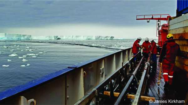
The answer the scientists of expedition PS134 can provide lies in using seismic profiling. The seismic team, along with the crew of Polarstern, withstood the cold Antarctic temperatures to deploy their equipment and obtain data that might help better understand how the WAIS and the Belgica Trough have been influenced by past glaciation and deglaciation periods.
The 3000 meter long seismic hydrophone cable (“streamer”) is spooled from the winch to the water. The team installs depth-control devices, also called “birds” due to their wings, at particular intervals along the streamer (photo and description by Karsten Gohl).
This type of geophysical surveying uses a seismic pulse source and a long cable of seismic hydrophone receivers able to capture this signal. The seismic source uses compressed air to emit energy which then penetrates the subsurface. Part of this energy is reflected by changes in the sediments below the seafloor. To receive this reflected energy, a 3000 m long cable was used. This equipment is called “streamer” and it is composed of hydrophones, which are capable of capturing the reflected signal. The received signal is then recorded in the seismic lab on board. Via this type of profiles, the seismic team has been able to visualize the deep sedimentary structures formed during the last few million years to analyse how oceanographic, geological and glacial changes have modified the submarine landscape.
This partial image of a yet unprocessed seismic profile shows a nice sequence of sedimentary rock layers on the continental shelf of the Bellingshausen Sea. These layered structures provide indications how and where early ice sheets pushed and deposited sediments. As soon as sophisticated data processing will be performed in the institute to remove the sea-floor multiples, sediment layers can be imaged down to several kilometers deep into the sub-bottom. (Description by Karsten Gohl.)
The region in which the Belgica was frozen in ice is of particular interest to the seismic team because this area is considered to have been affected by oceanographic conditions in the past, potentially by the intrusion of warm deep water. Previous seismic research has suggested that the intrusion of a warm deep ocean mass might have prevented the advance of the West Antarctic ice sheet about 34 million years ago during the so-called Eocene-Oligocene Transition.
The area in which the Belgica was trapped 125 years ago is presently affected by the intrusion of warm Circumpolar Deepwater (CDW). The development of this water mass and how it affects the WAIS is not yet fully understood, however, current research suggests that a retreat of the WAIS might be linked to modifications in strength, intensity, and pathways of the CDW.
In the seismic lab, Ingra, Pascal, Gabi and Thorsten check the control and survey data of the seismic profile on the monitors (photo and description by Karsten Gohl).
With their research the scientists of PS134 hope that evidences of how the WAIS has developed in the past during periods of cooling and warming might help us understand how the region reacts to climate changes. This will give us a hint of why the area where the Belgica was stranded 125 years ago is ice-free in the Antarctic summer of 2023.
This blog post was written by Ingra Barbosa, geophysicist at the Alfred Wegener Institute Helmholtz Center for Polar and Marine Research (Bremerhaven, Germany), and student-investigator in the PS134 geophysics team.
In this vlog episode, the various members of the marine geology team on board the PS134 RV Polarstern expedition explain which research activities they perform, and to what purpose. In a chronological order, you will meet Matthias Troch (UGent, Belgium), Dr. James Kirkham (BAS, UK), Lena Cardinahl (UBremen, Germany), Rosemary Burkhalter-Castro (University of South Florida, USA), Dr. Johann P. Klages (AWI, Germany), Zelna Weich (BAS and UCardiff, UK), Dr. Rob Larter (BAS, UK), and Dr. Claus-Dieter Hillenbrand (BAS, UK).
125 years ago, life onboard the RV Belgica was not simple. Especially during the polar night of 1898, when the Belgica was frozen solid in Antarctic sea ice from March 5th 1898 until March 14th 1899. The perpetual darkness and cold monotony of the polar night depressed the expedition members physically, mentally, and morally. Their total isolation and boredom led to melancholy, moody dispositions, and irritations. Consequently, most of the men coveted to solitude, although hard to come by in the Belgica’s cramped quarters. Moreover, the deadening effect of the Antarctic winter took a considerable toll on the men’s bodies, as all suffered from dizziness, headaches, insomnia, and various digestion issues. Soon these physical burdens led to exhaustion, which eventually tipped to depression by their constant fear of the sea ice. The Belgica was almost continuously groaning and creaking as her wooden hull was bending under the pressure of the convulsing sea ice. At any given moment, the sea ice could puncture the hull and sink the ship, leaving the early explorers stranded and without means to ever return.
The most worrisome were the cardiac arrhythmias which most of the men were suffering from. Worst-hit patient was Emile Danco, the expedition’s geophysicist, who had an old heart lesion noted by Dr. Cook as “a leak in one of the valves, which has been followed by an enlargement of the heart and a thickening of its walls”. Danco’s condition deteriorated fast, and Dr. Cook feared he would not live another month. In time, Danco’s kidneys started to fail as well. On June 5th 1898, Emile Danco passed away while holding the hand of Georges Lecointe, captain of the Belgica, but most importantly, one of Danco’s closest childhood friends. Emile Danco was wrapped in the Belgian flag, and given the southernmost funeral in history as he was lowered through a hole in the sea ice.
Dr. Cook’s photograph of the RV Belgica stuck in sea ice during polar night. The photograph was taken by moonlight on June 3th 1898, with an exposure time of an hour and a half. Credits: De Gerlache Family Collection, Zingem, Belgium.
Danco’s death dragged the men’s souls to abysmal depths, and the sailors were quickly demoralizing. As polar winter wore on, cognitive impairment continued, making all shipmates listless, unmotivated, disoriented, and incapable of concentrating on anything for more than a few seconds. Confidence in their future was lost, and many were on the brink of madness, as Henryk Arctowski noted in his diary: “We are in a mad-house”. Dr. Cook dedicated all of his time to determine the causes of this ship-wide illness. He believed the most critical factor was the disappearance of the sun, and called the general malaise that plagued the Belgica’s explorers “polar anaemia”. Dr. Cook therefore attempted to bring light to the Belgica, and ordered the men to stand naked in the glow of a blazing wood or coal fire. The “baking treatment”, as Dr. Cook called it, seemed in his opinion “the best substitute” for the absent sun. Although the flames of this fire weren’t as bright as the full-spectrum of the sun, Dr. Cook seemingly observed that some of the men’s moods, and even some of their physical symptoms, improved. The “baking treatment” was however not sufficient to resolve the damage of the Antarctic night, causing many of the men to remain bedridden, with signs of grave degeneration of both body and mind. To keep them active, Dr. Cook mandated the Belgica’s members to walk on the ice around the ship for an hour a day, an exercise the regimen nicknamed the “Madhouse Promenade”.
As weeks passed by, the Belgica eventually entered in the grip of scurvy. By far the most common cause of death on the sea during the time of early explorers, such as Columbus. Early symptoms were edema, paper skin, and foul breath, but these quickly transitioned into rotting gums, loosening teeth and joints, gangrene limbs, and old wounds to reopen. Scurvy is caused by a lack of vitamin C, however, proven remedies, like fresh citrus fruit, were not available onboard the Belgica. Based on his previous experience with living among the Inuit in northern Greenland, Dr. Cook prescribed a daily diet of fresh meat, most often penguin but occasionally seal, to be eaten raw. Eventually, those who followed Dr. Cook’s diet saw their symptoms improve.
Commander Adrien de Gerlache, with his face bloated due to scurvy. Credits: De Gerlache Family Collection, Zingem, Belgium.
This year, the RV Polarstern expedition members will fortunately not suffer from the physical, mental, and moral burdens the crew of the Belgica had to endure. First of all, the PS134 Polarstern expedition is currently operating in the almost ever-present daylight of the Antarctic summer, and will end before the polar night kicks in. Second, malnutrition will remain a far concern as, everyday onboard the RV Polarstern, at precisely 7.30 – 8.30, 11.30 – 12.30, 15.00 – 15.30 (coffee and cake break), and 17.30 – 18.30, we get well fed by our fantastic kitchen team. Even if you missed one of these moments because you were on shift, a (warm) dish will be waiting for you in the so-called “night kitchen”. The Polarstern is furthermore well equipped to keep its passengers physically fit, with amenities including a gym, sauna, small pool, and even a sunbed. Nonetheless, some of the Polarstern’s current passengers keep the promenade tradition alive by walking many numbers of rounds on the outside deck around the ship, as our gym facilities don’t provide an outdoor experience. But maybe the most important reason of our well-being is a certain future with a prospect to return home soon, an outlook the team onboard the Belgica was deprived of for many months.
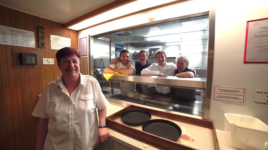
Meet Petra and her team of stewardesses and stewards: Martina, Romy, Erik, and Christoph, the 2nd cook! Every day they get up with a big smile to not only serve us food four times a day, but they are also the ones keeping our ship clean and fresh. We are spoiled to have them!
Meet the PS134 Southern Ocean Jellyfish (SO-Jelly) team! Jellyfish were already collected from the Bellingshausen Sea 125 years ago on board the Belgica, the first known records for this area. Sixty-one specimens from five different species were then collected during the Belgian expedition. Only sporadic jellyfish sampling occurred in the Bellingshausen Sea, jellyfish being still largely understudied in the whole Southern Ocean. Following the footsteps of the Belgica, the goal of my jellyfish team on board of Polarstern is to fill this knowledge gap. Besides the deployment of plankton nets, the advances in molecular and modelling techniques allows nowadays for a much more in depth understanding of the distribution, diversity, ecology, trophic role, and genetic connectivity of Antarctic jellyfish. From CTD deployments to collect water samples of different depths for environmental DNA analyses, to the collection, sorting, photographing of specimens, follow a day in the life of jellyfish researchers with this video.
When the RV Belgica got trapped in the pack ice of the Bellingshausen Sea in the beginning of March 1898, Adrien de Gerlache and his crew had no idea that they actually had got stuck in the ice just above the margin of a huge submarine trough carved into the seafloor about 600 m below their ship. The 75-150 km wide trough, which was named “Belgica Trough” in honour of de Gerlache’s expedition over a century after this event, extends for about 500 km across the continental shelf north of the Bryan Coast and English Coast in West Antarctica, thereby reaching water depths down to 1200 m close to the coast, ca. 600 m on the mid-shelf and ca. 650 m at the shelf edge. Sparse, high-resolution seafloor mapping in this region during less than a handful of research expeditions carried out by various countries (UK, US, Germany, South Korea) since the mid-1990s has revealed the presence of various morphological features (“bedforms”) on the floor of the trough that revealed the “footprint” of an enormous glacier in the past. During ice ages preceding the current warm period bedrock and seabed sediments in the vicinity of today’s coast had been eroded at the base of this so-called “Belgica palaeo-ice stream” before the eroded debris was deposited by the glacier further away from the coast. Thus, the existence of Belgica Trough with its bedforms gives testimony of repeated advances of ice masses grounded on the seafloor across the continental shelf during the past.
Bathymetry of the Bellingshausen Sea shelf with the location of Belgica Trough and topography under the Antarctic Ice Sheet landward of the coast (white lines: present coast lines and ice-shelf fronts, respectively) (Graham et al. 2011, The Cryosphere).
Although similar palaeo-ice stream troughs had been mapped elsewhere on the Antarctic continental shelf, Belgica Trough stands out because of several facts. First, taking into account its combined length, width and water depth, Belgica Trough is the largest palaeo-ice stream trough in Antarctica outside of the Ross Sea embayment. Estimates suggest that the area from which ice fed into the Belgica palaeo-ice stream during the last ice age may have been comparable to that of today’s Antarctic Peninsula Ice Sheet or reached nearly ten times the size of Belgium. Second, Belgica Trough was eroded by ice draining both the West Antarctic Ice Sheet (WAIS) and the Antarctic Peninsula Ice Sheet. The Antarctic Ice Sheet actually comprises three separate ice sheets, whose dynamic behaviour is quite different because of different conditions at their bases. The huge and thick East Antarctic Ice Sheet stores ice corresponding to 52 m of global sea level and rests predominantly above present sea level on the Antarctic continent, while the bed of the thinner WAIS, its “smaller brother”, holds ice corresponding to about 5.3 m of sea level and lies largely below sea level (= “marine based”). The Antarctic Peninsula Ice Sheet, the smallest of the Antarctic ice sheets, stores ice corresponding to just 0.3 m of global sea level and sits almost entirely above sea level on the continent. Third, in contrast to most other Antarctic palaeo-ice stream troughs, such as the Pine Island-Thwaites palaeo-ice stream trough located in the Amundsen Sea embayment directly to the west of the Bellingshausen Sea shelf, no major outlet glaciers drain into Belgica Trough today. This implies that during the present warm time only the tributary glaciers, which once fed into the huge Belgica palaeo-ice stream, remain.
Belgica Trough and its bedforms document the past dynamics of the WAIS and therefore may hold the key for predicting its future behaviour. The WAIS is considered inherently unstable and particularly vulnerable to global warming because its marine-based bed dips towards the interior of the Antarctic continent. Theoretical consideration indicate that under these conditions any retreat of the grounding line, i.e. the ice sheet’s marginal zone, where the ice starts to float, will inevitably lead to a runaway retreat, implying that the grounding line will withdraw even further landward until the entire ice sheet has eventually decayed. Studies of geological archives (e.g., fossil corals in tropical regions) have provided evidence that during warm periods of the past, such as a warm time ca. 125,000 years ago that preceded the last ice age, global sea level was at least 6 m higher than today. This sea-level highstand may have resulted from a “collapse” of the WAIS, with some minor contributions from ice-sheet loss in Greenland and East Antarctica.
Linear furrows (MSGL = Mega-Scale Glacial Lineations) carved by a huge glacier (named “Belgica palaeo-ice stream”) into the seafloor of Belgica Trough during the past ice age (Ó Cofaigh et al. 2005, J. Geophys. Res.).
Taking into account the overall instability of the WAIS, satellite data and in-situ measurements carried out in its Bellingshausen Sea drainage sector and the neighbouring Amundsen Sea drainage sector since the mid-1990s give raise for concern. The data show that over recent decades glaciers in these WAIS sectors have undergone dramatic thinning whilst their flow speeds accelerated and their grounding lines retreated, with grounding lines of Pine Island Glacier, Thwaites Glacier and other glaciers draining into the Amundsen Sea embayment having retreated by up to ca. 1 – 10 km/year. Most scientists think that the main reason for this alarming ice loss, which contributed about 7 mm to global sea-level rise from 2003 to 2019, is the ocean-induced melting of floating ice shelves stabilising the ice streams. This melting is caused by the inflow of relatively warm deep water onto the West Antarctic continental shelf. The reasons for the intensified “pumping” of the deep water onto the shelf and its variability over years and decades are not fully understood, yet, but changes in Southern Hemisphere wind systems due to atmospheric warming in response to increased anthropogenic greenhouse gas emissions are likely. Computer simulations suggest that the contribution of the Antarctic ice sheets to global sea-level rise by the year 2300 will be ca. 1.0 m as long as 21st warming does not exceed +1.5 °C, but will increase to 1.5 m, if this warming reaches +3 °C, with worst-case scenarios for future greenhouse gas emissions predicting a collapse of the WAIS and the marine based parts of the East Antarctic Ice Sheet, resulting in ca. 9.5 m sea-level rise.
Modelled contribution of Antarctic Ice Sheet melting to global mean sea-level rise above present (= Δ (GMSL)) until the year 2300 under the assumption of +1.5 °C (left) and +3.0 °C (right) global atmospheric warming, respectively (black line: mean predicted sea-level rise; blue shading: level of uncertainty, with darker shading illustrating higher probability) (DeConto et al. 2021, Nature).
Given the opportunity that the study of the Belgica palaeo-ice stream history offers for a better understanding of the dynamical behaviour of the WAIS and improving forecasts of global sea-level rise caused by current and future WAIS melting, Belgica Trough is a high-priority research target. The fact that no significant ice shelves exist along its south-western coast in Eltanin Bay alludes to the possibility that this region is a potential analogue for future environmental conditions in other WAIS sectors, such as the Amundsen Sea embayment, where major ice streams still exist but currently undergo major ice loss. In this respect, we may be able to learn more about the future fate of WAIS ice streams, such as Thwaites Glacier and Pine Island Glacier, by investigating the past fate of the ice stream that once occupied the area, where RV Belgica was trapped in the ice 125 years ago.
This blog post was written by Claus-Dieter Hillenbrand, marine geologist at the British Antarctic Survey (Cambridge, UK) and co-investigator of the PS134 marine geology team.
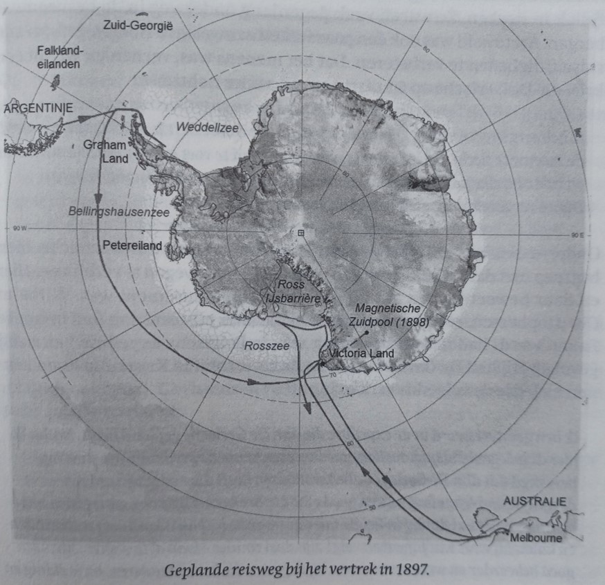
On February 28th 1898, commander Adrien de Gerlache and captain Georges Lecointe decided to go south, deep into Antarctic pack ice. This was a major change of plans as they were supposed to continue west following their initial itinerary. The pack ice was not their initial objective, their initial objective was to reach the coast of Victoria Land, where they would overwinter on land, and subsequently attempt to reach the Geomagnetic South Pole. These plans were however abandoned due to a series of unfortunate events, leading to considerable delays.
Initially planned itinerary of the RV Belgica expedition. Source: book “Adrien de Gerlache, a biography” by Jozef Verlinden.
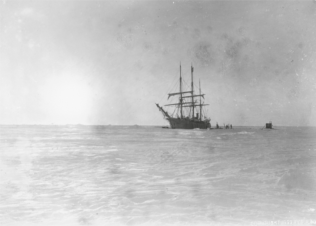
Their deliberate move into the dense sea ice was not without risk, and this was unanimously recognized by crew and scientists onboard the RV Belgica, who opposed de Gerlache’s and Lecointe’s plan to head south. One of the main risks of such a southward journey was to get stuck in the sea ice, which, under high-pressure conditions, could puncture the ship’s hull and sink it. Even if the RV Belgica would not suffer this fate, an endless entrapment in Antarctic sea ice could empty their rations and fuel reserves, leaving the crew and scientists to die of starvation and cold. However, as the Geomagnetic South Pole was out of reach, de Gerlache’s and Lecointe’s pursuit of glory had to be fulfilled with breaking an alternative record, being the farthest-south record of 78°09’30” south, which James Clark Ross set in 1842. Eventually, without the crew and scientists knowing, de Gerlache and Lecointe navigated the RV Belgica in a southern direction, condemning the expedition to an icy imprisonment. After traveling slowly through dense sea ice for days, on March 5th 1898, they got trapped, frozen, into the sea ice of the Bellingshausen Sea, not knowing when, worse if, they would ever escape.
RV Belgica trapped in the pack ice of the Bellingshausen Sea. Credits: Frederick A. Cook Society, Library of Congress (Washington, DC).
The crew and scientists onboard today’s PS134 expedition in that same Bellingshausen Sea will, fortunately, not suffer the same fate as the Belgica expedition, since we are onboard a 20,000 horsepower icebreaker ship equipped for sustained operations at temperatures down to -50°C and sea ice up to 3 m thick, but more importantly, Antarctic sea ice this year is projected to reach its record minimum since the satellite observations started 40 years ago.
RV Polarstern in this year’s sea ice free Bellingshausen Sea. Credits: Daniela Röhnert.
The sea-ice extent in the Southern Ocean around Antarctica will reach a worrying minimum this austral summer. The current extent of Antarctica’s sea ice is extremely low, and reflects a persistent, strong trend toward lower-than-average Antarctic sea-ice extent that started in 2016 (Parkinson et al., 2019 PNAS). The link between global warming and the decline of sea ice in the Southern Ocean is still unclear, but climate change can’t be ruled out as a driving factor.
Antarctic sea-ice extent since 1979 (Parkinson et al., 2019 PNAS).
The Antarctic sea ice reaches, in general, its yearly maximum extent in September or October, after which it starts to melt during austral summer, and reaches its minimum in February. During the Southern Hemisphere winter, the cold water of the Southern Ocean drives the growth of sea ice around Antarctica. During average conditions, the maximum extent of Antarctic sea ice is about 18 to 20 million square kilometers. During summer, it generally recedes to roughly 3 million square kilometers. At the beginning of February 2023, however, only 2.2 million square kilometers remained (Sea Ice Portal; https://www.meereisportal.de/), with melting to continue until at least the end of February.
Seasonal variations in Antarctic sea-ice extent (Raphael and Handcock, 2022 Nature Reviews Earth & Environment).
One of the causes of this intense melting could be the unusually high air temperatures around the Antarctic Peninsula, as the monthly average to the west and east of this peninsula is currently about 1.5°C above the long-term average. Another potential cause is the current strong positive phase in the so-called “Southern Annular Mode” (SAM), which influences the prevailing wind circulation in the Antarctic. In a positive SAM phase, a low-pressure anomaly forms over the Antarctic, whilst a high-pressure zone develops over the middle latitudes. Under such conditions, as we observe this year, the westerly wind belt intensifies and contracts toward the Antarctic. As a result, inflow of the relatively warm Circumpolar Deep Water on the continental shelf intensifies, promoting sea-ice retreat.
Although melting sea ice does not directly raise sea level, because the ice is already floating in the ocean, this year’s minimum is nonetheless concerning. Sea ice has a stabilizing effect on the Antarctic Ice Sheet and its surrounding floating ice shelves by providing a buffer to wave-induced flexure, a recent study in Nature shows (Massom et al., 2018). The increased seasonal absence of a protective sea-ice buffer causes floating ice shelves to be exposed to ocean swell waves, potentially weakening them to the point of calving. When these ice shelves calve, and ultimately disintegrate, the oceanwards flows of Antarctica’s glaciers and ice sheets accelerate, which eventually lead to an acceleration in global sea-level rise.
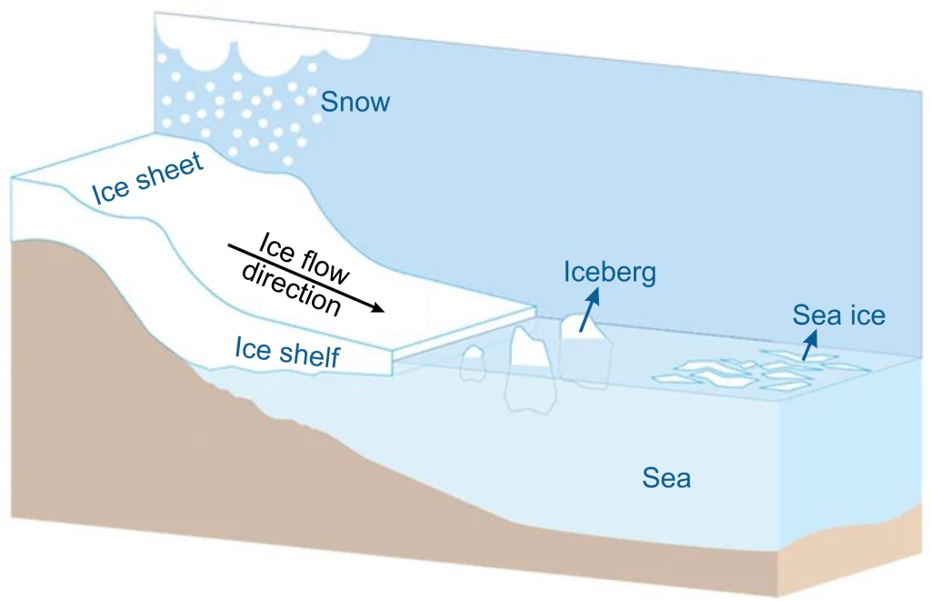
Sketch showing the various types of ice occurring in Antarctica.
The increased melt of sea ice furthermore aggravates warming in the Antarctic. The white, shiny surface of the sea ice reflects incoming solar energy back into space. The more the sea ice melts, the more of that energy is absorbed by the Southern Ocean, which, in turn, can melt even more of the ice.
The extent, growth, and decay of sea ice also plays a vital ecological role. Sea ice influences the growth of bacteria, phytoplankton, and algae, which form the base of the marine food chain. The ice moreover provides resting and breeding locations for marine mammals and birds, including seals and penguins. Fluctuations in sea-ice extent can therefore cause a series of changes throughout the Antarctic ecosystem, from the smallest microorganisms to the largest whales.
Historic documents highlight this year’s enormous fall in Antarctic sea-ice extent. Whilst the RV Belgica was stuck in the pack ice of the Bellingshausen Sea 125 years ago, in exactly the same region, our RV Polarstern can now operate in virtually ice-free waters. The photographs and diaries of the Belgica’s expedition members offer a unique chronicle of the ice conditions in the Bellingshausen Sea at the dawn of the industrial age, which climate researchers often use as a benchmark for comparison with today’s climate change.
The current ice-free conditions in the Bellingshausen Sea considerably facilitate the scientific activities of our PS134 expedition, and furthermore enable us to reach previously unexplored regions, on the other hand, this sea-ice absence underscores the urgency of modern changes observed around Antarctica.
The track of the RV Belgica 125 years ago (red) vs. the track of the RV Polarstern this year (white). Source bathymetric data: IBCSO International Bathymetric Chart of the Southern Ocean (Version 2, 2022)
Although geophysics and geology are the primary focus of our PS134 expedition, its biological component is perhaps smaller, but not less impactful. Today, I will therefore put in the spotlights the work conducted by my fellow biologists on board, which study a wide range of organisms, from microscopic diatoms, mysterious jellyfish, and zooplankton to gigantic whales.
But first, let’s rewind 125 years back and have a look at the biology covered during the Belgica expedition. A Titaness task that was left to only one man: the Romanian naturalist Emil Racovitza. Enlisted at the age 29 because of its obvious expertise on polar fauna and flora. Or so you would think. For all students out there wondering if their thesis topic was the right career choice, worry no more. Because you will never know where a college degree in law, followed by a career switch to natural sciences, resulting in publications on French marine worms (i.e., Annelids and Polychaetes), the behavior of crabs, and the reproduction of octopuses will lead you (I am not making this up). In the case of Racovitza, this brought him beyond the Antarctic circle on board of the Belgica, where his collections of botanical and zoological material would be the basis of numerous scientific reports published between 1900 and in 1949. Racovitza himself wrote two books, one on cetacean (i.e., whales and dolphins), and another unpublished one on pinnipeds (i.e., seals and sea lions). But as any researcher that ever took part in an expedition are (painfully) aware of, the work does not start at the beginning of the expedition. Scientific expeditions require an immense preparation work, long before its departure. For instance, in the case of my small jellyfish team, this required the packing of over 20 freight boxes and numerous plankton nets, six long months prior to our departure, Polarstern being luckily already equipped with lab spaces. The preparation work of Racovitza started already in August 1896, one year before the departure of the Belgica voyage. During this time, he oversaw the lay outs of the labs, planned the necessary research freight (including various camera and photography equipment), and the indispensable library. During the expedition, his work strongly focused on the behavior of marine mammals and sea birds. But if you think that a great Belgian Antarctic expedition would have led to the description and the naming of some fancy new seal or penguin species, then you don’t know my country. Nicknamed the country of surrealism, it is only appropriate that we ended up with Belgica antarctica, aflightless midge fly.
Emil Racovitza, naturalist on board of the Belgica. His valuable botanical and zoological data collected during the expedition would lead to countless of scientific reports published between 1900 and 1949. Picture credit: De Gerlache Family Collection
But let’s go back to 2023. With Antarctica in summer holding some of the main feeding grounds of countless whales, it is no surprise that here on board of the Polarstern, similar as to the Belgica expedition, there is a strong focus on marine mammals. The “whale team” is composed of three marine biologists (Nadya Ramirez Martinez, Johannes Baltzer, and Klaus Lucke), one veterinarian (Luca Schick), and two drone pilots (Chris Stevenson, and John Newton). Their goal is to study how the distribution, behavior and relative abundance of different marine mammal species changes in the vicinity of the ship due to sound propagation in the area. For this, they are using a combination of ship observations, aerial observations with helicopters and drones (weather dependent), and hydroacoustics (sounds recorded underwater from hydrophones attached to a mooring). The four most frequently spotted marine mammals during our expedition so far comprised Antarctic minke, humpback, and killer whales, and many seals, mostly crab-eater seals. As marine mammals are considered “umbrella” species (i.e., a wide-ranging species whose requirements include those of many other species), the study of these animals can then help as a proxy, to understand the state of the oceans.
A crab-eater seal spotted during our expedition, one of the most common seal species in the area. Their name is however misleading, as they feed primarily on fish. Picture credits: Pascal Daub.
As a marine biologist studying jellyfish, I am here to convince you that marine mammals are not the only charismatic critters swimming around these waters. Despite the importance of gelatinous zooplankton (generally known as “jellyfish”) in marine pelagic systems, these animals stayed largely understudied in the Bellingshausen Sea. Thus, the goal of my “jellyfish team” is to study the distribution, diversity, ecology, trophic role, and genetic connectivity of Antarctic jellyfish. To do so, we collect various specimens using plankton nets and water samples for environmental DNA analyses (i.e., traces of DNA organisms leave in their environment). But you will learn more on our jellyfish work, in a future special dedicated vlog. Besides the collection of jellyfish, we also catch quite diverse zooplankton species. And since we were talking about whales before, I wanted to share a magnificent picture of a krill or “whale food” caught within our Bongo plankton nets.
Antarctic krill, or “whale food”, caught with our plankton nets. Picture credits: Joan J. Soto-Àngel
From zooplankton, we can even go smaller, down to the microscopic diatoms, studied on board by Zelna Weich. These single cell algae are characterized by beautiful glass shells (made of silicate), making fine and intricate patterns. In Antarctica, their life cycle is often tightly linked with the sea ice, in which some species grow. Eventually the diatoms will die and sink to the bottom of the ocean, forming layers of diatoms, from which we can estimate the past abundances of different species. Studying these layers will then provide local information on past sea ice growth and retreat, at up to a decadal resolution, well prior to the use of satellites to survey ice coverage. This is of particular importance to be able to predict the future of the Antarctic ice cover, which unlike the Arctic, has been acting in a very erratic manner under recent climate events, alternating between more dramatic ice buildup and losses. These diatom layers can also indicate past algae blooms, which are typically linked to an increase of sea productivity, which has benefitted all the way up the food chain, from grazing zooplankton, to predating jellyfish and to krill eating whales. As you can see, all marine life in the Antarctic is connected. At least through their stomachs.
Example of an Antarctic Sea ice associated diatom, Thalassiosira antarctica (left), and a cosmopolitan Southern Ocean Sea ice avoiding species, Fragiliariposis kerguensis (right). Pictures credit: Zelna Weich.
During the Last Glacial Maximum, i.e., the culmination of the last ice age about 20 thousand years ago, the entire seabed in the shallow part of the Bellingshausen Sea (the so called continental shelf) was covered by the Antarctic Ice Sheet. When this ice retreated after the last ice age, it left traces behind on the seafloor in the form of morphological features shaped by the ice and a cover of glacial sediments. Within this deglaciated sea, the glacial sediments eventually got buried below a drape of marine sediments. Today, the marine geology team onboard the RV Polarstern samples these glacial-marine sediment sequences using a gravity corer to reconstruct when and how fast the Antarctic Ice Sheet retreated after the last ice age. This reconstruction is done via three consecutive steps in the laboratory. First, after the recovery of the sediment cores, they are scanned to measure their physical properties, including density, magnetic properties, and sound velocity. Next, the cores are split, their lithological composition is described, and discrete sediment samples are taken, on which various other parameters, such as water content, grain size, etc., are measured. These data are then used to identify the subglacial sediments, which had been deposited under the ice sheet, and the marine sediments deposited on top of them, and locate the transition between them in the core. Finally, calcareous microfossils, such as foraminifera, are extracted from the marine sediments. By measuring the content of radiocarbon in the shells of these microfossils, their age and thus the age of the sediment can be determined. Ultimately, this temporal data is used to identify the age of ice retreat at the core location. By repeating this analysis along a core transect extending through the Bellingshausen Sea from today’s ice sheet front towards the continental slope, the marine geology team can reconstruct the retreat pattern of the Antarctic Ice Sheet after the Last Glacial Maximum. In addition, the PS134 marine geologists analyze fossil diatom (siliceous phytoplankton) assemblages, and other sedimentological and geochemical properties, to reconstruct past environmental changes in response to the ice retreat. The figure below shows a sketch explaining the concept.
Sketch explaining the working strategy of the PS134 marine geology team. Disclaimer: this sketch shows our working principle, not real results, nor the reverse bed slope causing the ice sheet to be particularly vulnerable to global warming. Credits: Matthias Troch.
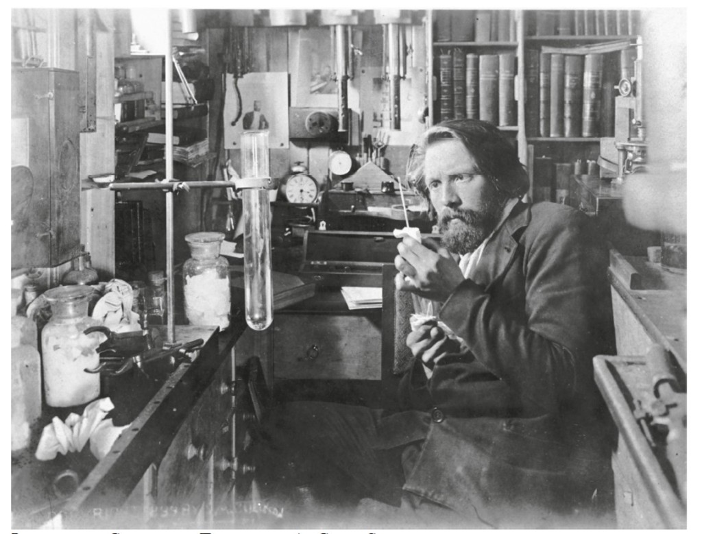
One of the first geologists to discover evidence of this more extensive and older Antarctic Ice Sheet was Henryk Arctowski, geologist onboard the Belgian Antarctic expedition of 1897-1899. Arctowski was a Polish earth scientist affiliated with the University of Liège (Belgium), and he was hired by commander Adrien de Gerlache to coordinate the scientific work onboard the RV Belgica’s Antarctic expedition. During their exploration of the Gerlache Strait from January 23rd until February 12th 1898, Arctowski described and mapped numerous ancient moraines, i.e., arcuate formations made of debris deposited along the edge of former glaciers and ice sheets. These landforms provided irrefutable evidence for a larger and more extensive glaciation along the Antarctic Peninsula at some time in the past. Unfortunately, back in Arctowski’s days, absolute dating techniques to determine the moraines’s ages were not yet developed.
The marine geology team onboard the PS134 RV Polarstern expedition, from left to right and top to bottom: Lena, Rob, Claus-Dieter, Matthias, James, Johann, Norbert, Zelna, Rosemary, and Kenza.Henryk Arctowski in his lab onboard the RV Belgica during the Belgian Antarctic expedition of 1897-1899. Credits: Library of Congress, Frederick A. Cook Society.
Both the original research of Henryk Arctowski and today’s investigations by the PS134 team are highly relevant in the context of contemporary and future climate change. Namely, the contribution of ice loss from the Antarctic Ice Sheet to global sea-level rise is projected to reach up to 3.3 meters by the year 2100 in the worst-case scenario (graph below; Bakker et al 2017 Scientific Reports). This contribution is mainly due to the melting of the West Antarctic Ice Sheet, which drains together with the Antarctic Peninsula Ice Sheet into the Bellingshausen Sea. As the West Antarctic Ice Sheet sits predominantly below sea level on the Antarctic continent, it is considered as inherently instable and particularly vulnerable to global warming. A considerable uncertainty, however, remains on how fast the West Antarctic Ice Sheet will recede in the future and contribute to world-wide sea-level rise, as its stability is controlled by a complex interaction between various processes, including destabilization of floating ice shelves (which are buttressing ice resting on land), inflow of warm ocean water, marine ice sheet instability (i.e., fast ice retreat over a reverse bed slope), ice cliff failure, and surface melting on ice shelves triggered by warm air temperatures that results in so called “hydrofracturing”, i.e., fragmentation of ice-shelves caused by the refreezing of the meltwater in crevasses within the ice shelves. By investigating geological archives, earth scientists, such as Henryk Arctowski and the PS134 team onboard the RV Polarstern, aim to constrain past configurations of the Antarctic Ice Sheet, its previous retreat rates, and mechanisms triggering its retreat. Their geological results are eventually used by numerical modelers to calibrate computer simulations and improve quantitative forecasts of future ice sheet change and sea-level rise. Via this interdisciplinary collaboration between earth scientists and numerical modelers, we aim to better forecast the future by learning from the past.
Future global sea-level projections including the uncertain contribution of the West Antarctic Ice Sheet, following RCP8.5 (Representative Concentration Pathway). RCP8.5 is considered the worst-case greenhouse gas concentration trajectory adopted by theIntergovernmental Panel on Climate Change (IPCC). Red curve: West Antarctic Ice Sheet remains intact; yellow curve: mid-range estimate; dark red curve: full West Antarctic Ice Sheet disintegration within a couple of decades causing an additional global sea-level rise of 3.3 meters by the year 2100. Figure from Bakker et al., 2017 (Scientific Reports).